The information in this guidance was obtained from the National Oceanic and Atmospheric Administration’s National Weather Service offices, other federal agencies as well as State of Wisconsin agencies in the event of severe weather and tornadoes.
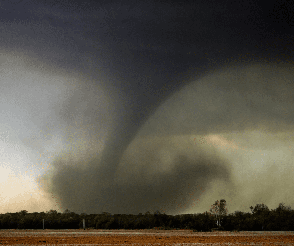
Tornadoes can occur any time of year. Wisconsin averages 23 tornadoes annually, according to the National Weather Service. The peak tornado season in the state is May through August.
This document outlines the critical importance of safeguarding the lives of students, families, staff and visitors in the event of tornadoes and severe weather.
Preparing Before Severe Weather Occurs
Preparedness begins before severe weather strikes.
It is important to know the difference between watches and warnings.
Tornado Watch
A tornado watch is used when tornadoes are possible in your area, and you should be alert for approaching severe weather. This is the time to be prepared.
- Know your safe place (storm shelter, basement, interior hall away from windows).
- Be ready to act quickly if a Warning is issued.
Be Prepared.
Tornado Warning
A tornado warning is issued when a tornado has been sighted or indicated by weather radar in your area. This is the time to take action!
- Immediately seek shelter in your safe place!
Take Action!
Hazardous Weather Outlooks are issued daily from the National Weather Service and can alert you of expected hazards out to seven days in the future. Outlooks are available in both graphical form or a text format. These outlooks are also broadcast over NOAA Weather Radio between 6 a.m. and Noon.
Make sure you have multiple ways to receive weather warning information to ensure you receive the information even if one system isn’t working or cannot be accessed due to circumstances or accessibility.
- Wireless Emergency Alerts – These are short messages sent to any Wireless Emergency Alert enabled mobile device. These are sent to geographically targeted areas and will appear like text messages on your device. Weather alerting information is sent from your local National Weather Service office.
- NOAA Weather Radio All Hazards – This is a nationwide network of radio stations that broadcast continuous weather information from the nearest National Weather Service office. See Attachment 1 for your NOAA radio frequency in Wisconsin.
- Local broadcast radio or television – Many local news stations will broadcast weather alert notifications. Local TV news stations will also broadcast live on-air and online weather coverage once a tornado warning is issued.
- Mobile and desktop apps – Use a trusted weather app to be notified of severe weather alerts.
- Local alert messaging – Some communities have sign-up alert notification services such as Nixle or CodeRed. Please reach out to your county emergency management office to see if a service is provided for your area.
- Outdoor warning sirens – Outdoor warning sirens may not be reliable for alerting people inside buildings due to background noise, insulation, or HVAC system. These sirens are operated by municipalities, tribes, or counties. They are not regulated nor controlled by the state.
Develop a Severe Weather Safety Plan
Every school should have a severe weather safety plan. If you currently do not have a severe weather action plan for your school, your county emergency management director or the National Weather Service (NWS) can assist in this process and provide guidance. The plan should also include practice drills and annually review the plan.
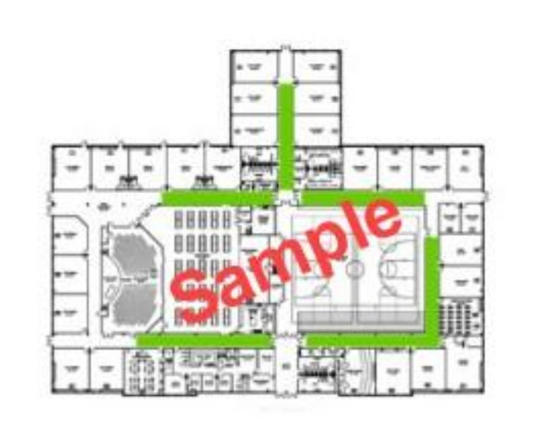
The plan for your school will have to be tailored to your particular setup. Closely examine the layout of your buildings. You’ll need to determine your designated shelter areas. Use a map of the school and physically tour the building(s) with your top school officials. You may also want to invite local fire department personnel, emergency management, or a building engineer to assist.
Ideally students should be moved to the lowest level(s) possible or designated tornado safe room if part of the school building. If those are not options:
- Use interior rooms on the lowest floor and away from windows. Hallways that have doors to the outside can act as wind tunnels, so avoid these areas.
- Avoid exterior classrooms or rooms with many windows.
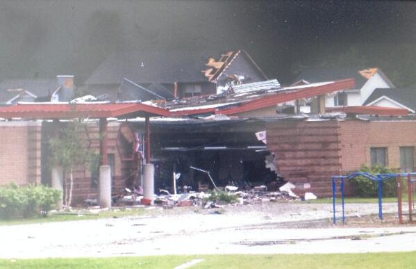
- Avoid large span ceiling rooms like gymnasiums, auditoriums, and cafeterias. You must assume ceiling failure will occur.
- Avoid portable classrooms.
There are many things to consider when mapping out your shelter areas. Also consider non-routine school activities or other times the buildings are being used.
- Travel Time – You should pick shelters where you can get students safely inside within three minutes. This will depend on the number of students, distance from the shelter, amount of space, students with special needs, etc.
- Size or Space – Ensure you have enough space to fit the number of students assigned to that shelter. Consider times of the day, class sizes, and special needs of students so you can handle each case. You may have to designate several shelters in different regions or zones of your building to accommodate everyone. Don’t forget the school staff as well.
- Construction – Review the quality of construction to ensure sturdy protection. Look for possible failures in the ceilings. Rooms with a sky light should usually be avoided.
Develop a method to notify everyone to seek shelter. It could be a speaker system, special tone, or bell, but ensure you have a backup method in the event you lose electricity. Also consider how to notify during non-routine school activities, such as sporting events or dances. Ensure everyone clearly knows what the notification signal is. Shelters should be clearly marked as such, with arrows directing people to the “safer” areas.
Also include in your plan what bus drivers should do while at school or during transportation. Work with your school bussing company on those procedures.
Practice Your Plan
You should practice and review your severe weather and tornado action plan relatively often.
If your plan is new, a few practice run-throughs are suggested in case you need to revise shelter choices before finalizing it.
Your plan should be reviewed at least annually, and anytime changes are made to the physical building, shelters, or classroom sizes.
A good chance to practice is during the annual statewide Tornado Drills held in late March to mid-April each spring.
Inform parents of your action plan which might involve students remaining or delayed at school beyond regular hours if severe weather is threatening.

Ensure students know the protection position. During a tornado, the protection position for students is to crouch low on the ground, with their head down, and arms covering the back of their head and neck.
During the Storm: Take Action!
If a tornado warning is issued, immediately seek safety and put your tornado safety plan into action. If time allows, take note of problems that develop while the plan is being used.
Do not go near windows when a tornado warning is issued. Do not try to open windows or doors to equalize pressure. The pressure difference in a storm is not what damages buildings – it is the strong wind and flying debris associated with the storm or tornado that will cause damage and could explode glass or exterior walls.
Continue to monitor weather conditions until you are sure tornado threat has passed.
After the Storm: Assess and Review
Once you are confident the tornado threat has passed, assess the building(s) for damage before releasing people from their shelter areas. Check exterior areas including playground areas. If damage is noted, you may need to keep people in the shelter location or relocate them to safe areas.
Make sure you announce an “all clear” message or other pre-determined signal to alert students, staff, or people in shelter areas it is safe to return to their previous locations.
Lightning Safety for Coaches and Officials
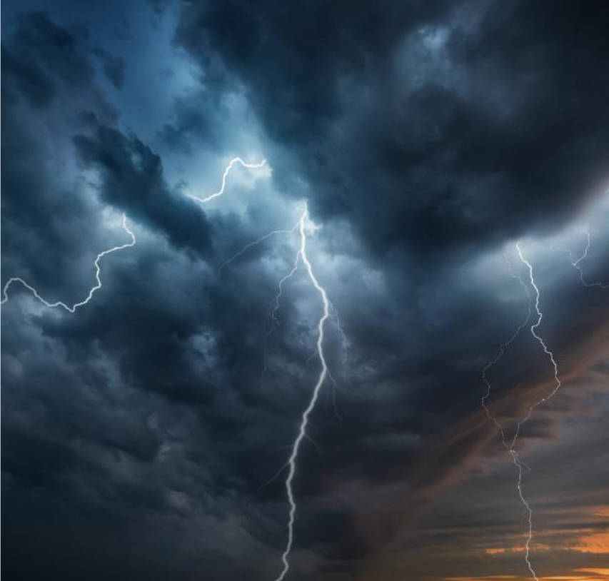
All thunderstorms produce lightning and are dangerous.
Lightning kills about 20 people each year in the United States and hundreds more are injured. Some survivors suffer lifelong neurological damage. Since 2003, there have been 10 lightning-related deaths in Wisconsin.
For organized outdoor activities, the National Weather Service recommends that organizers have a lightning safety plan and follow it without exception. The plan should give clear and specific safety guidelines to eliminate errors in judgment. These guidelines should address the following questions.
- When should activities be stopped?
- Where should people go for safety?
- When should activities be resumed?
- Who should monitor the weather and make the decision to stop activities?
- What should be done if someone is struck by lightning?
When Thunder Roars Go Indoors
Lighting Fatalities from Outdoor Sports
- 40% Soccer
- 27% Golf
- 17% Running
- 10% Baseball
- 3% Football
- 3% Other
Step 1
Leave the field immediately
Step 2
Seek shelter in an enclosed building or car
Wait 30 minutes after the last rumble of thunder to return outside
Before an event or activity, organizers should check the weather forecast to see if thunderstorms are likely.
If thunderstorms are expected, organizers should think about canceling or rescheduling the event. Sometimes, the event can be moved indoors. Once people start arriving, the safety rules for lightning should be followed.
Officials should keep an eye on the weather, radar, and lightning detection tools for any storms that might be coming.
When should activities be stopped?
In general, a significant lightning threat extends outward from the base of a thunderstorm cloud about 6 to 10 miles. It’s important to account for the time it will take for everyone to get to safety. Here are some criteria that could be used to stop activities.
- If you see lightning. The ability to see lightning varies depending on the time of day, weather conditions, and obstructions such as trees, bluffs, etc. In clear air, and especially at night, lightning can be seen from storms more than 10 miles away if obstructions don’t limit the view of the thunderstorm.
- If you hear thunder. Thunder can usually be heard for about 10 miles if there is no background noise. Traffic, wind, and precipitation may limit the ability to hear thunder to less than 10 miles. If you hear thunder, though, it’s a safe bet that the storm is within ten miles.
- If the skies look threatening. Thunderstorms can develop directly overhead and some storms may develop lightning just as they move into an area.
Where should people go for safe shelter?
There is no place outside that is safe when a thunderstorm is in the area.
Stop the activity immediately and get to a safe place immediately. Substantial buildings with wiring and plumbing provide the greatest amount of protection. Office buildings, schools, and homes are examples of buildings that would offer good protection. Once inside, stay away from windows and doors and anything that conducts electricity such as corded phones, wiring, plumbing, and anything connected to these.
Note that small outdoor buildings including dugouts, rain shelters, sheds, etc., are NOT SAFE. In the absence of a substantial building, a hard-topped metal vehicle with the windows closed provides good protection.
When should activities be resumed?
Because electrical charges can linger in clouds after a thunderstorm has seemingly passed, experts agree that people should wait at least 30 minutes after the last thunder before resuming outdoor activities.
Who should monitor the weather and make decisions?
Lightning safety plans should specify that someone be designated to monitor the weather for lightning. The lightning monitor should not be the coach, umpire, or referee, because these people will be busy and can’t adequately monitor conditions. The lightning monitor must know the plan’s guidelines and be empowered to assure that the guidelines are followed.
What should be done if someone is struck by lightning?
Most victims can survive a lightning strike; however, they need immediate medical attention. Call 911 for medical help. Victims do not carry an electrical charge. In many cases, the victim’s heart and/or breathing may have stopped. CPR or an AED may be needed to revive them. Continue to monitor the victim until medical help arrives. If possible, move the victim to a safer place inside away from the threat of another lightning strike.
Attachment 1: NOAA Weather Radio Frequencies
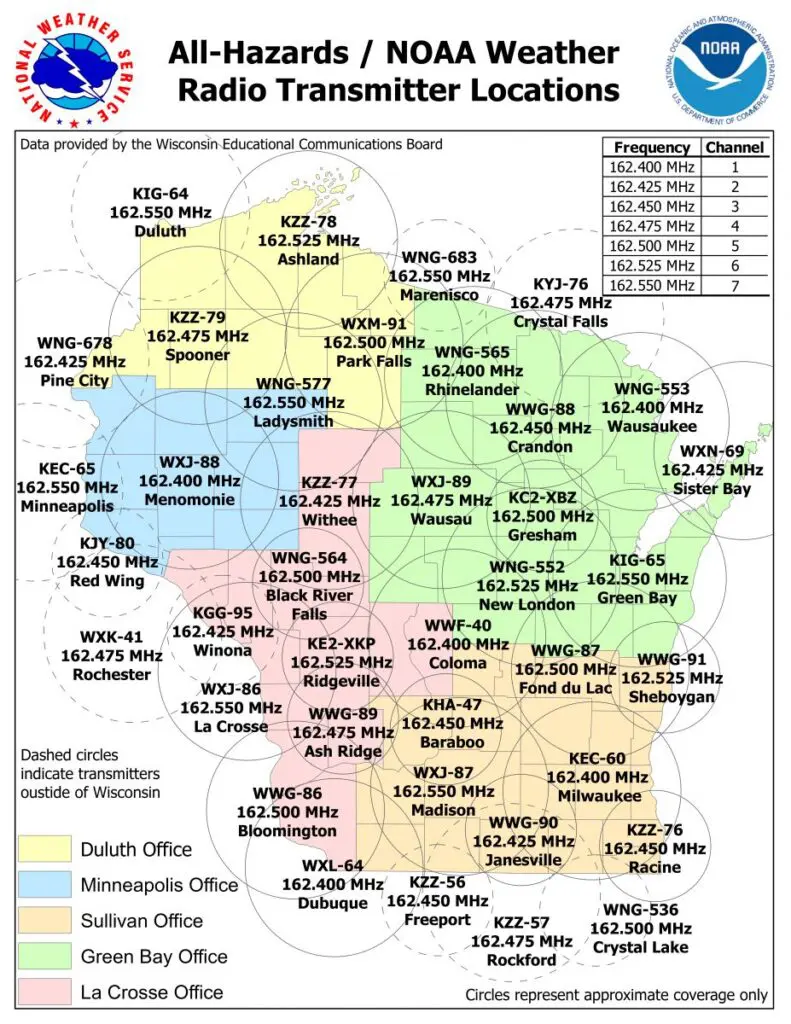
| # | Transmitter | Office | ID | FREQ | Notes: |
|---|---|---|---|---|---|
| 1a | Milwaukee | Sullivan | KEC-60 | 162.400 MHZ | |
| 2a | Madison | Sullivan | WXJ-87 | 162.550 MHZ | |
| 3a | Fond Du Lac | Sullivan | WWG-87 | 162.500 MHZ | State Funded |
| 4a | Sheboygan | Sullivan | WWG-91 | 162.525 MHZ | State Funded Half Power Transmitter |
| 5a | Janesville | Sullivan | WWG-90 | 162.425 MHZ | State Funded Half Power Transmitter |
| 6a | Racine | Sullivan | KZZ-76 | 162.450 MHZ | State Funded Half Power Transmitter |
| 7a | Baraboo | Sullivan | KHA-47 | 162.450 MHZ | Half Power Transmitter |
| 1b | Bloomington | La Crosse | WWG-86 | 162.500 MHZ | State Funded |
| 2b | Pleasant Ridge | La Crosse | WWG-89 | 162.475 MHZ | State Funded Half Power Transmitter |
| 3b | Black River Falls | La Crosse | WNG-564 | 162.500 MHZ | Half Power Transmitter |
| 4b | La Crosse | La Crosse | WXJ-86 | 162.550 MHZ | |
| 5b | Rochester | La Crosse | WXK-41 | 162.475 MHZ | |
| 6b | Withee | La Crosse | KZZ-77 | 162.425 MHZ | State Funded |
| 7b | Winona | La Crosse | KGG-95 | 162.425 MHZ | Half Power Transmitter |
| 8b | Tomah-Ridgeville | La Crosse | KE2XKP | 162.525 MHZ | State Funded Half Power Transmitter |
| 1c | Door County | Green Bay | WXN-69 | 162.425 MHZ | State Funded |
| 2c | Green Bay | Green Bay | KIG-65 | 162.550 MHZ | |
| 3c | Crandon | Green Bay | WWG-88 | 162.450 MHZ | State Funded |
| 4c | Wausau | Green Bay | WXJ-89 | 162.475 MHZ | |
| 5c | Wausaukee | Green Bay | WNG-553 | 162.400 MHZ | |
| 6c | Rhinelander | Green Bay | WNG-565 | 162.400 MHZ | |
| 7c | New London | Green Bay | WNG-552 | 162.525 MHZ | |
| 8c | Coloma | Green Bay | WWF-40 | 162.400 MHZ | State Funded |
| 9c | Gresham | Green Bay | KC2XBZ | 162.500 MHZ | State Funded Half Power Transmitter |
| 1d | Chicago | Chicago | KWO-39 | 162.550 MHZ | |
| 2d | Rockford | Chicago | KZZ-57 | 162.475 MHZ | |
| 3d | Crystal Lake | Chicago | KXI-41 | 162.500 MHZ | Half Power Transmitter |
| 1e | Dubuque | Davenport | WXL-64 | 162.400 MHZ | |
| 2e | Freeport | Davenport | KZZ-56 | 162.450 MHZ | Half Power Transmitter |
| 1f | Minneapolis | Minneapolis | KEC-65 | 162.550 MHZ | |
| 2f | Menomonie | Minneapolis | WXJ-88 | 162.400 MHZ | |
| 3f | Ladysmith | Minneapolis | WNG-577 | 162.550 MHZ | |
| 4f | Red Wing | Minneapolis | KJY-80 | 162.450MHZ | |
| 5f | Eau Claire | Minneapolis | ? | ? | Proposed State Funded Half Power Transmitter |
| 1g | Duluth | Duluth | KIG-64 | 162.550 MHZ | |
| 2g | Park Falls | Duluth | WXM-91 | 162.500 MHZ | State Funded |
| 3g | Spooner | Duluth | KZZ-79 | 162.475 MHZ | State Funded |
| 4g | Ashland | Duluth | KZZ-78 | 162.525 MHZ | State Funded |
| 5g | Pine City | Duluth | WNG-678 | 162.425 MHZ | |
| 1h | Marenisco | Marquette | WNG-683 | 162.550 MHZ | Half Power Transmitter |
| 2h | Crystal Falls | Marquette | KJY-76 | 162.475 MHZ | Half Power Transmitter |
This information was published in 2025 by ReadyWisconsin with input and review by the following National Weather Service Forecast Offices: Duluth, Green Bay, La Crosse, Milwaukee, and Minneapolis.